GPS-based Child Tracker with Emergency Text Alerts IoT Project

The hectic life of parents makes it very difficult to personally look after the kids. To overcome the problem of personal monitoring of children, we have come up with the idea of a GPS-based tracker with text alerts when the child is not present in the specified region.

Problem Statement:

To solve the problem of difficulty in keeping a check on children while they are playing in open areas while letting the children have their freedom to play from constantly being mocked by parents and to monitor the whereabouts of children by working parents. There is a similar project on Women Security System that can be seen here

Project Working Process:

Hardware Components

  • Arduino UNO
  • GPS Module
  • GSM/GPRS Module 

Software’s Used

  • Arduino IDE
  • Android (MIT App Inventor)

In this context, the solution we propose is a GPS-based Child Tracker with Emergency Text Alerts android application that can help parents in tracking the presence of their children. This application works with the help of android mobile-enabled with the ‘SMS’ feature and ‘Global-Positioning System (GPS)’ on the GSM network.

This Child Tracker with Emergency Notifier application works in two ways, the first is GPS-based is related to Location services, and the second is SMS-based which is related to Network services. In case when the Location-based services not working then the application alternatively use Network-based services that can send and receive messages.

Block Diagram:

CHILD TRACKER WITH EMERGENCY NOTIFIER Block Diagram

The GSM and GPS module is connected to Arduino Uno. The GSM module has a sim (data) through which we can receive message alerts and the GPS helps to track the location.

The data is sent to the cloud from GSM using AT commands and HTTP. The cloud is connected to the mobile app and the data is displayed in the app installed on the parent’s mobile.

Useful Projects on Self Security in Emergency Situations:

Self Security through GPS based Protection System

Stay Safe Women Security Android App Project Report

The GPS-based Child Tracker with Emergency Text Alerts app is integrated with maps and geo-fence.

The GPS is connected to Arduino using a VCC pin, GND pin, RX pin, and TX pin. Connections: VCC to 3V3, GND to GND, RX to TX, and TX to RX respectively. GSM is connected to Arduino using VCC, GND, RX, and TX pins. Connections: VCC to 5V, GND to GND, pin 3 to TX, pin 4 to RX respectively.

A tiny GPS++ library is included. Using IBM cloud (node-red flow editor) the data is sent to a mobile app developed using MIT app inventor.

Automatic Vehicle Accident Alert System using IBM Cloud

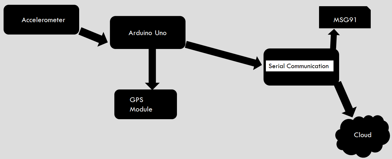
In this Automatic Vehicle Accident Alert System project, we are using Node MCU, Arduino UNO, Accelerometer, and GPS module to store the location of the vehicle and to send an immediate alert message to the nearby hospitals, police stations…etc. Here we use serial communication to send the information from Arduino to Node MCU.

The Arduino receives the latitude and longitude values of the vehicle from the GPS module. The accelerometer reads the XYZ axis values. These values are read by Arduino. The XYZ values are compared with the condition given in the code to check whether the vehicle is met with an accident or not.

If the vehicle is met with an accident, latitude, and longitude values are copied to the NodeMCU, and the message is sent to the nearby police stations, and hospitals using the msg91 application. The GPS location of the vehicle is continuously stored in the IBM cloud.

Block Diagram:

Block Diagram of Vehicle Accident Detection

Hardware components:

  • Arduino
  • Node MCU
  • GPS Module- NEO-6m
  • Accelerometer- ADXL-335

Software Components:

  • Arduino IDE
  • IBM Cloud
  • msg91

A Smart & Secure Helmet IoT Project

Abstract

This Smart & Secure Helmet IoT Project is aimed at using the concept of the Internet of Things (IoT) and chemistry with the rider’s helmet to provide extensive safety, guidance, and health care features. The following features are planned to be implemented in a phase-wise manner in the project :

1. Internet of Things(IoT) based traffic emergency system

2. Internet of Things(IoT) based traffic guidance system

3. Extensive protection from sunstrokes

4. GPS tracking

All these facilities are to be implemented on the helmet with maximum cost efficiency to make the final product within the reach of the Indian common man.

Goal

The goal of this project is :

  • To provide advanced traffic safety mechanisms through IoT to the people at affordable costs.
  • To provide IoT-based traffic guidance system to the people – first target: Tier-1 cities in India
  • To provide extensive protection from sun strokes, especially during the hot summer season in India
  • To make this project an innovative platform for many other applications like Easy GPS tracking, Health sensor, etc.

Motivation

There has been a multiple-fold rise in the number of road accidents in recent days and many times, emergency services have faced difficulty in a timely response to the situation.

In large cities, sometimes the emergency services find it difficult to locate the spot of the accident based on a phone call.

Companies(logistics, customer service) face difficulties in tracking the vehicles of their employees

Even with the heavy risk of not wearing a helmet, People do it as they find it inconvenient to wear a helmet in hot humid sub-Continent conditions. Our new chemical system compartment in the helmet solves it.

All these situations prompted us to look into the possibility of IoT coming up helping people in these cases and we found out that in the initial phases of our project, we can use the helmets used by people while driving. Later the same technology can be used on other vehicles to provide an all-around extensive safety mechanism.

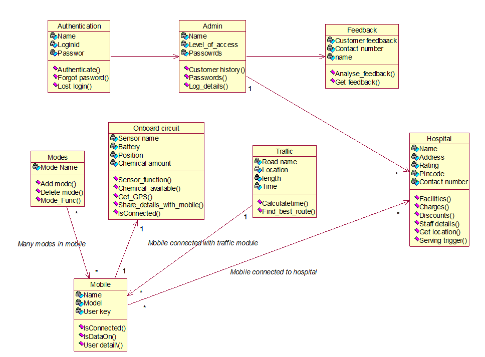
Class Diagram:

ADVANTAGES

The helmet will be mounted with appropriate sensors at appropriate positions on the helmet. They are calibrated to sense high impact due to an accident or crash.

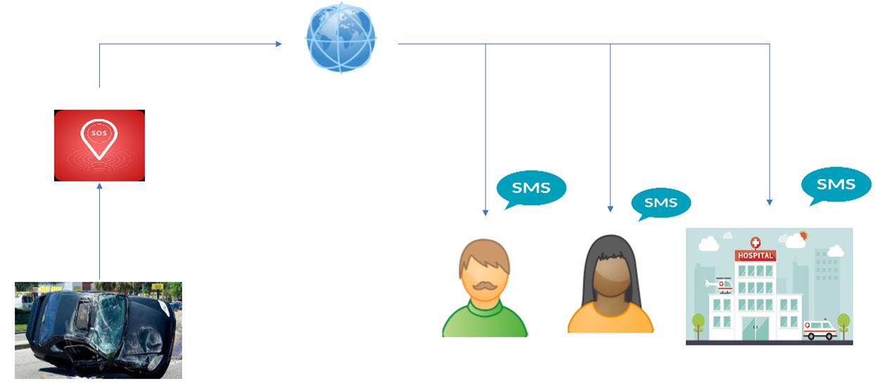
Once they detect the designated input, the rider’s location is immediately sent to a cloud of hospitals, and the nearest hospital is notified about that so that the ambulance can reach the spot immediately.

1. Immediate response to any accident by the emergency services since all of them become a part of the network (of things).

2. The location of the accident is too updated to the emergency services so that finding the location won’t be much trouble.

3. Details of the personnel are also updated to the emergency service center so that formalities of paperwork may be completed beforehand.

4. Continues tracking of employees for Companies like logistics, customer service, etc.

5. Proper Traffic Guidance using Google Services.

6. Humidity reduction inside Helmet.

7. Many inbuilt Bluetooth facilities like automatic call acceptance (while driving) etc.

Conclave on the Internet of Things provided us with exposure to the applications of the concept of the Internet of Things (IoT) and several other creative approaches that solve day-to-day problems by invoking the interconnection and sharing between the day-to-day products.

Apart from the conclave, we would like to appreciate the suggestions and help from the faculties which proved to be a priceless booster to our project.

We are a team dedicated to the research and development of creative solutions to day-to-day problems. We aim at creating smart, simple, innovative ad cost-effective solutions which could be affordable for the common man of India.

Future Work

PROTOTYPE-II: To implement a traffic guidance system using Google services.

PROTOTYPE-III: To implement a fully integrated traffic safety and guidance system

Cloud-enabled Vehicle Theft and Accident Detection System Project

For vehicle theft, in this project for the opening of the door we first click on the button, after a few seconds we get an OTP (random number) generated by Arduino through the GSM module to the phone number stored in the Arduino, we again text back the same random number.

After some time the OTP will be checked, if it’s correct the door will be opened, in our Vehicle Theft and Accident Detection System project the servo motor rotates, if it’s wrong the buzzer will ring indicating someone is opening or stealing the vehicle

A mobile phone is also used for the owner’s interaction with the device installed in the vehicle, so that, when the owner wants to track the vehicle, only he/she can do it.

PROPOSED WORK

In this Cloud-enabled Vehicle Theft and Accident Detection System Project work, we use the accelerometer to detect the position on different axis (to detect the toppling condition) of the vehicle during an accident. The output of the accelerometer acts as an input to the microcontroller present on the board. The GSM & GPS module fitted onto the device computes the latitude and longitude value for the vehicle. The time, latitude, and longitude values are recorded periodically. The sensor value is transmitted to the cloud in the event of an occurrence of an accident.

A continuous application runs in the background and recursively compares each vehicle’s sensor field to some standard value. A deviation from the standard value retrieves the address of the location from the last updated longitude and latitude via the API.

The occurrence of an accident is promptly reported to nearby hospitals and the police through the messaging service. With the GSM and GPS module installed in the device, the location of the car can be tracked in real-time, which helps the police to recover a stolen car.

Download the complete CLOUD-ENABLED-VEHICLE-THEFT-AND-ACCIDENT-DETECTION-SYSTEM source code, Project Report, PPT, and Output Video Files and Android apk.

Accident identification based alerting location over GSM and GPS Project

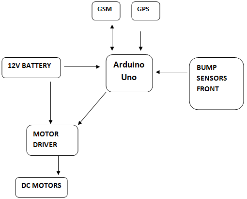
This proposed project work is an attempt to design an advanced vehicle security and tracking system that can identify vehicle accident detection and sends the location details using GPS and GSM.

In present existing models many vehicles do not have accident detection system they have to wait for someone help to inform our guardians, this is a very big problem in 4 wheelers so to over all these we have developed a prototype model which has accident detection system in from in front and back side of the vehicle when they get pressed that indicates accident detected.

In this Accident identification based alerting location over GSM and GPS project we have used Arduino UNO open-source motherboard to which we have interfaced accident detection switch GSM modem SIM 800L for sending the message when accident detected, and GPS is for getting the location accident place, and in this accident identification project we have used an airbag which will get open when an accident is detected and the vehicle gets stopped automatically.

The safety of the vehicle This complete system is designed taking into consideration the low range vehicles to provide them with extreme security.

Block Diagram:

Vehicle Security System with Engine Locking and Alerting Project

Synopsis:

This system is an attempt to develop an advanced vehicle security system that can identify vehicle theft and can track the details using GPS and GSM modules.

In present existing security systems strangers can enter the vehicle and take it without starting the engine, the vehicle owner will not be able to identify when the stranger doesn’t start the vehicle, if stranger removes the battery connections then entire security system will be an off state. It is very difficult to identify the vehicle in this situation.

Here we are proposing the new security system for 4 wheelers, which will have given security to the vehicle.

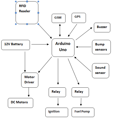
In this model vehicle will have RFID reader inside the car beside driver seat once after you enter the vehicle you have to keep the RFID tag in RFID reader for clearing the security check, if the RFID tag is matched then vehicle ignition will be on else alert signal will be sent to car owner along with location with help of GPS and GSM. (GPS for location identification and GSM for message sending) and the car will make emergency sound with a buzzer, engine ignition and fuel pump will get off with help of a relay.

If any stranger tries to open the door we have sensors like sound which will detect the sound like when a stranger breaks glass or hit with hammer etc… we have bump sensors in the bumper of the vehicle which will notify when cars meet an accident.

Block Diagram:

GSM and GPS based Smart File Security System

Abstract:

The main aim of this Smart File Security System project is to design and development of a certificate folder tracking system. The tracking devices are GSM and GPS modules. The GSM and GPS tracking system are one of the modern accurate tracking devices. Our design comprises with the Arduino MC that controls whole the system.

These devices are used to locate the particular location of the objects such as lost certificate folder, identification of lost keys and send their coordinates to the user through an SMS. GSM digitizes and compresses the data, then sends the data to a channel in its own time slot. It operates at 1800 MHz frequency band. GPS receiver collects the information to calculate the user’s exact location.

The tracking devices are used to locate particular objects using GPS (Global Positioning System).The design consists of GSM and GPS system to track the location of the object. By arranging this tracking device in the objects like folders, briefcase etc. the user could track their location from time to time. This makes the user find his belongings within less time.

The design is done in such a way that the system could be arranged in less space and accurate in tracking locations. As there is a GSM slot in the design, the user could get coordinates of the object from time to time through SMS. The design consists of an alert system to find an object by the sound.

The size of the microcontroller can be decreased, and it can be arranged in the small objects. As this project is based on a microcontroller, GSM, and GPS. This project is developed with low cost by integrating GSM and GPS.

The system consists of different modules which are linked wirelessly with GSM modules. Cost effective SMS service of GSM network is used for transfer of data between the modules. This service provides the information about the location of the place, of the certificate folder.

Working operation of project

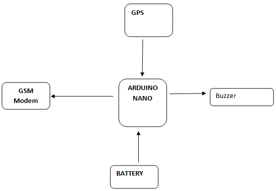
In this project we are using Arduino nano as microcontroller unit for reading and sending the data, We have GPS NEO 6M for getting the current location of module and this is interfaced to Arduino nano to pin 2 and pin 3, GPS NEO 6M will send the serial data in NEMA format to Arduino nano, and Arduino nano will take longitude and altitude values, whenever the GSM modem receives the message it is sent to Arduino nano and this will send the GPS location to sender (file owner).

GSM modem will be connected to Arduino nano to pin 0 and pin 1 RX and TX, Arduino nano and GSM SIM 800 and Arduino nano will communicate each other with AT Commands, GSM modem will have SIM card. We have small piezoelectric buzzer integrated into the file for easy identification of file with the sound indication.

Applications:

• Certificate files.
• Property document files
• Other Important log data files etc…

Conclusion:

This project is very useful as compared to existing file folders system which can track the file with small SMS with help of GPS system. This project can be further modified to IOT for more easy access with android application.

Automatic Meter Reading System Project Using GPRS

In Automatic meter reading system project using GPRS, we implemented a GPRS Automatic Meter Reading System in order to enhance security for the electrical suppliers in controlling the unauthorized electrical power usage. Web services based GPRS automatic meter reading provides better solutions for the managements in meter reading of power consumptions accurately with no scope man made errors.

The architecture of web services based GPRS automatic meter reading system is designed using microprocessor, Remote Reading Units (RRU), telephone network i.e. Communication Front End (CFE). The meter readings were collected by the remote reading units and transferred to the communication front end systems at the control system and billing is done.

Need of Automatic meter reading systems:

  • In order to prevent the bogus seals and tampering of seals.
  • To reduce Meter tampering, meter tilting, meter interface.
  • To control Meter bypassing.
  • To limit the connection changing’s and Direct tapping from line.

Various Automatic meter reading techniques:

In AMR metering technologies we transmit data from transmitter end to receiver end by means of RF technology.

There are various AMR techniques like handheld computer, touch based AMR, Mobile or Drive-by meter reading, Fixed Network AMR, Radio frequency based AMR, Power Line Communication PLC type AMR system, and Wireless Fidelity (Wi-Fi) based AMR.

Youtube video link cover block diagram , system architecture..etc

http://www.youtube.com/watch?v=qny6MIpvVJ4&feature=youtu.be

Benefits of AMR technologies:

When compared to conventional metering systems automatic metering systems are quite advantageous in terms of  eliminating meter reading costs in manual operations, presenting interference free data transfer from the meter reading units to the billing units, and these are cost effective reliable and free from excess human involvement.

Download Automatic Meter Reading System Project Using GPRS Full Report

Implementation:

The sample model is implemented in a high performance technical computing MATLAB language. The system design is done by SIMULINK software in MATLAB. The process of selecting blocks and initializing them is clearly explained in the coming sections.

Web Based Vehicle Tracking System Using GPS Major Project for B.tech ECE Students

Introduction to Web-Based Vehicle Tracking System Using GPS Major Project:

Tracking frameworks were first advanced for the delivery industry on account of they had a desire to confirm where every vehicle was at any given time. Detached frameworks were improved first and foremost to satisfy the proposed prerequisites.

For the requisitions which need ongoing area informative content of the vehicle, the proposed frameworks can’t be utilized on account of the recovery the area informative content in the inner space and area qualified information can just be entered when the vehicle is ready.

To realize Automatic Vehicle Location framework that can transmit the area qualified information continuously, Active frameworks are improved. Constant vehicular tracking framework consolidates an equipment gadget instated in the vehicle (In-Vehicle Unit) and a remote Tracking server.

The informative data is transmitted to Tracking server utilizing GSM/GPRS modem on GSM arrange by utilizing SMS or utilizing coordinate TCP/IP association with Tracking server through GPRS. Tracking server additionally has GSM/GPRS modem that appropriates vehicle area informative data through GSM arrange and archives this qualified information in the database. This qualified data is ready to commissioned users of the framework by means of online presence over the virtual world. 

The outcomes exhibited in this paper hold execution of Startup schedule, execution of SMS Configure schedule, Logs of Tracking Server and Pointing out the current area of the vehicle. For vehicle tracking progressively, in-vehicle unit and a tracking server are utilized.

The informative content is transmitted to Tracking server utilizing GSM/GPRS modem on GSM arrange by utilizing SMS or utilizing regulate TCP/IP association with Tracking server through GPRS.

Tracking server moreover has a GSM/GPRS modem that gains vehicle area qualified information by means of the GSM system and archives this informative data in the database. This informative content is ready to commissioned users of the framework through web space over the web. Right now In-Vehicle unit was executed with two sheets.

Microcontroller slat was remotely joined to GM862-GPS interface plank. Single slat could be planned to fuse Microcontroller hardware on the GM862-GPS interface plank. It will lessen the on the whole size of the In-Vehicle unit and it will moreover decrease the number of parts so will the expense.

Smart Offers Engine on Mobiles B.tech CSE Project in Java with Abstract

Introduction to Smart Offers Engine on Mobiles Project:

As per the present system the advertising of the retail outlets is made in order to attract people and these ads are based on paper prints thus making it possible to reach the customers of all levels. Mobiles are nowadays available at affordable rates for all customers thus making it possible for them to advertise in mobile ways. This is also a smart way of advertising. This application provides various advantages like firstly it allows the owners of these retail outlets to push the new offers in front of the mobile users.

On the basis of the time set by the owners of the outlet users are provided with various mobile offers. Thirdly, on the basis of the location of the users users are entitled to get various offers. Fourthly, it also makes it easy for the customers to view the offers and make sure whether they are valid or not. At the same time it can also compare with other offers. smart offer engine and view offers are the other two parts of the system.

The implementation of a “SMART OFFERS ENGINE ON MOBILES” is possible only with the downloading of an application onto the mobile that relates to a particular server and thus making it easy for the interchange of information. The pushing of the offers by the retailers are possible only with the mobile smart offers and this facility depends on the time and location of the users. To get the services based on the time and location the phone should enable the GPRS and GPS service.

The mobile app will detect the server and send a message requesting for the offers at a specified outlet. This is possible only when the device is present in the surrounding press of the outlet. This is further sent in the form of SMS to the mobile phone and as the GPS service is supported in mobile handsets then the appliance can be used to detect the server’s location.