Real-Time Map-Based Pollution Monitoring and Data Management System

Title : Real-Time Map-Based Pollution Monitoring And Data Management System

Introduction: For years, pollution has been a major issue faced by mankind and it is increasing by the day. The recent pollution disasters that happened in major cities across the globe have taught us one thing and that is, that it is important to keep an eye on the pollution that is increasing day by day. Many government and global organizations have started to work on it and almost a decade has passed since these programs have been functioning. But, the major issue with these organizations is that they are focused on beating pollution on every front whether it is air pollution or water pollution.

These organizations are more focused on amending laws for pollution control and the monitoring process boils down to analyzing air quality and then making changes in the environmental laws. Also, the issue is that these bodies are controlled by the central or federal government. But, pollution is no longer an issue that can be tackled gradually and conventionally. It needs immediate attention and effective monitoring is required so that the authorities can take necessary measures to solve the pollution problems.

The pollution problem is more persistent in urban metropolitans and metros. But, municipal corporations have very little control over the situation because of a lack of data to act upon. Recent developments in the smart city sector are also encouraging cities to develop monitoring systems. The city of Ahmedabad, Gujarat has implemented digital signboards that show the real-time value of major air pollutants and overall air quality. This data is displayed to the people driving on the road so that they can take necessary precautions to avoid or minimize the health risks due to pollution. But, this kind of Pollution Monitoring project requires a huge amount of funds and is also not feasible everywhere.

So we are building a minimalistic model to tackle the issue of monitoring pollution. Our main goal is to provide real-time data visualization and also provide a database that will store all the data and provide readings of various pollutants. The data will be visualized through the means of a map hence it would be easy to pinpoint the exact location when any kind of action is needed. We will also build a device to capture data and then feed it into a web application that can be used to monitor and visualize the data.

The main aim of this Real-Time Map-Based Pollution Monitoring project is to provide a centralized repository of sensor data and also to create an effective and centralized monitoring system. The low cost and feasibility of the project make it easy to use for both smart cities as well as small towns. Furthermore, this kind of monitoring system will allow for the development of effective countermeasures and control strategies for keeping the pollution problem in check.
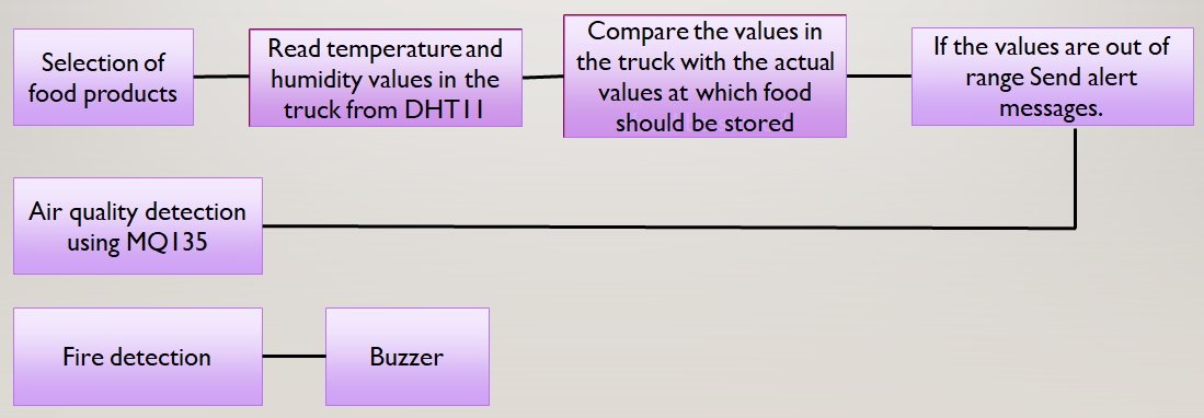
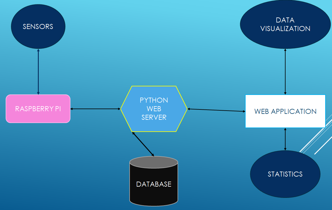
Process Flow:

Pollution Monitoring System Process Flow

Methodology

Methodology

This Real-Time Map-Based Pollution Monitoring project is aimed at local authorities like the municipal corporation rather than the central government so that immediate action can be taken by them to control the pollution problem.

This Pollution Monitoring project can be briefly divided into three main parts:-

  • Data Collection.
  • Data Monitoring.
  • Data Storage.

1. Data Collection:

Data collection is an important part of this Pollution Monitoring System project. Any kind of monitoring system is functional only because of the data that has been provided to it.

Data collection will be consisting of reading data from sensors. Now, from the research conducted, we have been able to deduce the major kind of data that we need. Looking at the urban pollutants we have observed that the most prominent pollutant is the Particulate Matter (PM) and Suspended Particulate Matter (SPM).

Hence we have decided to use a DSM501A Particulate Matter and Suspended Particulate Matter Sensor for detecting PM(2.5) or Particulate Matter, which is one of the major pollutants. Also, it leads to various lung and carcinogenic diseases and skin problems.

Particulate Matter concentrations have raised dramatically in the past decades to increase the number of automobiles on urban roads. Hence we have decided that monitoring PM/SPM (Particulate Matter and Suspended Particulate Matter) is going to be one of the main agendas of our monitoring system.

Another major pollutant that has been identified is Carbon Monoxide (CO). Now, CO is not just a single pollutant but, it is also responsible for creating another harmful pollutant i.e Ozone (O3). Ozone is important for blocking UVs from the sun but, at the ground level, the Ozone is a dangerous gas. Carbon Monoxide is specifically dangerous as it affects the hemoglobin if the concentrations exceed 35 ppm (parts-per-million).

From the research we have done, it has been clear that CO is present in spatial quantities but, that means that we need to effectively monitor it to keep its concentrations at safe levels. We will be using an MQ-7 sensor for measuring Carbon Monoxide.

Studies have pointed out that SO2 and NO2 are also major air pollutants and contribute to the degradation of overall air quality. Also, several hydro-carbon compounds are pollutants although not major, affecting the air quality a lot. Hence we have decided to use an MQ-135 sensor to monitor SO2 and NO2 levels as well as the overall air quality.

The sensors will be interfaced on a Raspberry Pi and their data will record using the GPIO library (Python). The data from these sensors will then be directed to the web server and the storage.

2. Data Monitoring:

Data Monitoring is the key component of the system. To monitor the data we have decided to use Google Maps so that the position of our Raspberry Pi Module can be pinpointed and then by using color-coding we can determine the levels of pollution in the vicinity of our Raspberry Pi Module.

All of this will be achieved by creating a web server in Python using the Flask framework and the main desktop app will be a web application written in HTML, CSS, Bootstrap, and JavaScript. The desktop app will have three options

  1. Map-Based Monitoring
  2. Individual Pollutant Monitoring
  3. Statistics

3. Data Storage:

Data Storage is necessary to reference past data and develop statistics from them. The data will be stored locally on the file system and can be downloaded in the form of excel sheets.

Timeline 

Serial Number

Tasks

Duration

1.

Synopsis and Presentation Submission

15 days

2.

Component Purchasing and Testing

15 Days

3.

Interfacing sensors and writing server script

15 days

4.

Writing Front-End Application

15 days

5.

Integrating Front-End and Back-End services

15 days

Components

  • Raspberry Pi model B
  • SD card and adapter
  • MQ-7 sensor
  • MQ-135
  • DSM501A


Development of IoT Project on Intelligent Cargo Management System

The integration of such sensors in cargo has paved the way for intelligent transportation. These integrated systems are competent in delivering reliable details about the quality of the goods during their depository time.

To reach this goal, we use a variety of sensors suited for monitoring the safety of food products and goods by recording the transition of parameters like temperature, humidity, and air quality, fire detection.

This information is transmitted wirelessly to the IBM cloud providing an interface where the authorized person can observe the product quality over time and also receives alert messages in case of bad air quality and abnormal conditions.

Block Diagram:

Block Diagram of Intelligent Cargo Management System

An Intelligent Cargo Management System app is designed for selecting the type of goods to be stored in the truck, for door automation, and for retrieving the values from the sensor.

Initially, the authorized person of the truck has to select the type of goods stored in the truck through the Cargo Management System app. Based on the selection, the temperature and humidity values at which the goods are supposed to be stored will be known. Using the DHT11 sensor, the actual temperature and humidity inside the truck can be known.

The temperature and humidity values can be obtained from the app. By comparing these values, a message will be sent to the authorized person asking him/her to turn on the AC or the heater in any abnormal conditions.

The air quality inside the truck is constantly monitored using MQ135 sensor. If the quality of the air inside the truck is bad, a message is sent to the authorized person regarding the same.

Through this goods can be maintained in constant conditions and their quality is maintained for a longer time. A fire sensor is also deployed in the truck to detect fire. If the fire is detected, the buzzer rings alerting the driver of the fire. The door of the truck is automated using a servo motor.

The authorized person of the truck can open or close the door of the truck using the Cargo Management System app.

GPS-based Child Tracker with Emergency Text Alerts IoT Project

The hectic life of parents makes it very difficult to personally look after the kids. To overcome the problem of personal monitoring of children, we have come up with the idea of a GPS-based tracker with text alerts when the child is not present in the specified region.

Problem Statement:

To solve the problem of difficulty in keeping a check on children while they are playing in open areas while letting the children have their freedom to play from constantly being mocked by parents and to monitor the whereabouts of children by working parents. There is a similar project on Women Security System that can be seen here

Project Working Process:

Hardware Components

  • Arduino UNO
  • GPS Module
  • GSM/GPRS Module 

Software’s Used

  • Arduino IDE
  • Android (MIT App Inventor)

In this context, the solution we propose is a GPS-based Child Tracker with Emergency Text Alerts android application that can help parents in tracking the presence of their children. This application works with the help of android mobile-enabled with the ‘SMS’ feature and ‘Global-Positioning System (GPS)’ on the GSM network.

This Child Tracker with Emergency Notifier application works in two ways, the first is GPS-based is related to Location services, and the second is SMS-based which is related to Network services. In case when the Location-based services not working then the application alternatively use Network-based services that can send and receive messages.

Block Diagram:

CHILD TRACKER WITH EMERGENCY NOTIFIER Block Diagram

The GSM and GPS module is connected to Arduino Uno. The GSM module has a sim (data) through which we can receive message alerts and the GPS helps to track the location.

The data is sent to the cloud from GSM using AT commands and HTTP. The cloud is connected to the mobile app and the data is displayed in the app installed on the parent’s mobile.

Useful Projects on Self Security in Emergency Situations:

Self Security through GPS based Protection System

Stay Safe Women Security Android App Project Report

The GPS-based Child Tracker with Emergency Text Alerts app is integrated with maps and geo-fence.

The GPS is connected to Arduino using a VCC pin, GND pin, RX pin, and TX pin. Connections: VCC to 3V3, GND to GND, RX to TX, and TX to RX respectively. GSM is connected to Arduino using VCC, GND, RX, and TX pins. Connections: VCC to 5V, GND to GND, pin 3 to TX, pin 4 to RX respectively.

A tiny GPS++ library is included. Using IBM cloud (node-red flow editor) the data is sent to a mobile app developed using MIT app inventor.

Home Safety and Security System Using IoT Project

The main objective of the Home Safety and Security System Using IoT project is to implement a home safety and security system with the following features:

  • Monitoring and detection of leaks in LPG gas
  • Unauthorized opening of door/window

Hardware Requirements:

The hardware for the project consists of:

GISMO-V board with:

  • ESP32 dual-core 32-bit processor with Wi-Fi and BLE
  • MQ6 sensor module
  • Magnetic switch assembly
  • 0.96” OLED display with 128×64 resolution

Cloud Platform:

In this project, we are going to use Google’s firebase as a cloud database. It is a No-SQL database in which data is stored as Key-Value pairs.

To access the database the following credentials are required

  • Host URL
  • Database authentication key

These credentials are put into the ESP32 firmware to access the Google Firebase.
The keys used to store the parameter values in the project are:

  • IOTLAB/HSSS/Gas_Leak
  • IOTLAB/ HSSS/Window_Open

Mobile App:

  • The Modular rapid mobile app development utility is used for the development of the mobile app. The utility has two modes, a Developer mode, and a Blocks mode. Different functional blocks are available in developer mode, they are – User Interface, Sensors, Connectivity, Firebase, and so on.
  • In the Blocks mode, a timer with timing set to two seconds will fetch the LPG gas concentration and magnetic switch status values from the Firebase database and fill it in the appropriate place in the UI.
  • To access the Firebase dataset its credentials will be placed in the Firebase component of the Modular app.

Mobile App development of Home Safety and Security System Using IoT Project

Results and Conclusions:

With the help of the MQ6 sensor and magnetic switch, we monitored the leakage in LPG gas and also the window/door open status.
We can get notified with the help of the mobile app.

Download the complete Home Safety and Security System Using IoT Project code, report, ppt, design document, and SRS.

A Smart & Secure Helmet IoT Project

Abstract

This Smart & Secure Helmet IoT Project is aimed at using the concept of the Internet of Things (IoT) and chemistry with the rider’s helmet to provide extensive safety, guidance, and health care features. The following features are planned to be implemented in a phase-wise manner in the project :

1. Internet of Things(IoT) based traffic emergency system

2. Internet of Things(IoT) based traffic guidance system

3. Extensive protection from sunstrokes

4. GPS tracking

All these facilities are to be implemented on the helmet with maximum cost efficiency to make the final product within the reach of the Indian common man.

Goal

The goal of this project is :

  • To provide advanced traffic safety mechanisms through IoT to the people at affordable costs.
  • To provide IoT-based traffic guidance system to the people – first target: Tier-1 cities in India
  • To provide extensive protection from sun strokes, especially during the hot summer season in India
  • To make this project an innovative platform for many other applications like Easy GPS tracking, Health sensor, etc.

Motivation

There has been a multiple-fold rise in the number of road accidents in recent days and many times, emergency services have faced difficulty in a timely response to the situation.

In large cities, sometimes the emergency services find it difficult to locate the spot of the accident based on a phone call.

Companies(logistics, customer service) face difficulties in tracking the vehicles of their employees

Even with the heavy risk of not wearing a helmet, People do it as they find it inconvenient to wear a helmet in hot humid sub-Continent conditions. Our new chemical system compartment in the helmet solves it.

All these situations prompted us to look into the possibility of IoT coming up helping people in these cases and we found out that in the initial phases of our project, we can use the helmets used by people while driving. Later the same technology can be used on other vehicles to provide an all-around extensive safety mechanism.

Class Diagram:

ADVANTAGES

The helmet will be mounted with appropriate sensors at appropriate positions on the helmet. They are calibrated to sense high impact due to an accident or crash.

Once they detect the designated input, the rider’s location is immediately sent to a cloud of hospitals, and the nearest hospital is notified about that so that the ambulance can reach the spot immediately.

1. Immediate response to any accident by the emergency services since all of them become a part of the network (of things).

2. The location of the accident is too updated to the emergency services so that finding the location won’t be much trouble.

3. Details of the personnel are also updated to the emergency service center so that formalities of paperwork may be completed beforehand.

4. Continues tracking of employees for Companies like logistics, customer service, etc.

5. Proper Traffic Guidance using Google Services.

6. Humidity reduction inside Helmet.

7. Many inbuilt Bluetooth facilities like automatic call acceptance (while driving) etc.

Conclave on the Internet of Things provided us with exposure to the applications of the concept of the Internet of Things (IoT) and several other creative approaches that solve day-to-day problems by invoking the interconnection and sharing between the day-to-day products.

Apart from the conclave, we would like to appreciate the suggestions and help from the faculties which proved to be a priceless booster to our project.

We are a team dedicated to the research and development of creative solutions to day-to-day problems. We aim at creating smart, simple, innovative ad cost-effective solutions which could be affordable for the common man of India.

Future Work

PROTOTYPE-II: To implement a traffic guidance system using Google services.

PROTOTYPE-III: To implement a fully integrated traffic safety and guidance system

School Bag Security Device Microcontroller Project

Bag Security is a device developed in partial fulfillment of the course of Microcontroller and its applications that gives an indication to the owner whenever the Bag zip is opened when it is carrying. This School Bag Security project also displays the number of books in the bag which is useful for children below 10 years to verify whether they are carrying the same number of books they bought from home or not.

CIRCUIT DIAGRAM:

OUTPUTS IN BOTH PROTEUS AND HARDWARE:
CASE 1: INCREMENT OF BOOKS:

EXPLANATION:

For increment first, the IR sensor1 will be detected and then IR sensor2 will be detected then only the book will be increment. IR sensor1 should be placed near the bag zip and IR sensor2 should be placed below the IR sensor1.

This shows the connections for our project left side two switches are IR sensors and the left side two switches are one switch and another IR sensor

CASE 2: DECREMENT OF BOOKS:

EXPLANATION:

For Decrement first, the IR sensor2 will be detected and then IR sensor1 will be detected then only the book will be decrement. IR sensor1 should be placed near the bag zip and IR sensor2 should be placed below the IR sensor1.

CASE3: WHEN ZIP IS OPEN:

EXPLANATION for case3:

The buzzer should ring only when we are carrying the bag and also when the zip is opened the truth table explains that. So, we kept the switch on the bag Zip and the Ir sensor below the zip inside the bag. When the switch is on and also the Ir sensor detects the light then the buzzer or LED will be ON.

CONCLUSION:

We have designed a device that will ring the buzzer only when we are carrying the bag and also when the zip is opened. And also, we have included an LCD which displays the number of books in the Bag.

COMPONENTS USED:

  • Microprocessor development board
  • AT89C51
  • IR SENSOR
  • LCD

Download School Bag Security Project

This project was developed with an 8051 Microcontroller.

Cloud-enabled Vehicle Theft and Accident Detection System Project

For vehicle theft, in this project for the opening of the door we first click on the button, after a few seconds we get an OTP (random number) generated by Arduino through the GSM module to the phone number stored in the Arduino, we again text back the same random number.

After some time the OTP will be checked, if it’s correct the door will be opened, in our Vehicle Theft and Accident Detection System project the servo motor rotates, if it’s wrong the buzzer will ring indicating someone is opening or stealing the vehicle

A mobile phone is also used for the owner’s interaction with the device installed in the vehicle, so that, when the owner wants to track the vehicle, only he/she can do it.

PROPOSED WORK

In this Cloud-enabled Vehicle Theft and Accident Detection System Project work, we use the accelerometer to detect the position on different axis (to detect the toppling condition) of the vehicle during an accident. The output of the accelerometer acts as an input to the microcontroller present on the board. The GSM & GPS module fitted onto the device computes the latitude and longitude value for the vehicle. The time, latitude, and longitude values are recorded periodically. The sensor value is transmitted to the cloud in the event of an occurrence of an accident.

A continuous application runs in the background and recursively compares each vehicle’s sensor field to some standard value. A deviation from the standard value retrieves the address of the location from the last updated longitude and latitude via the API.

The occurrence of an accident is promptly reported to nearby hospitals and the police through the messaging service. With the GSM and GPS module installed in the device, the location of the car can be tracked in real-time, which helps the police to recover a stolen car.

Download the complete CLOUD-ENABLED-VEHICLE-THEFT-AND-ACCIDENT-DETECTION-SYSTEM source code, Project Report, PPT, and Output Video Files and Android apk.

Obstacle Avoidance Voice Controlled Robotic Vehicle Project

This Obstacle Avoidance Voice Controlled Robotic Vehicle Project work is mainly based on Arduino, Motor driver, and Bluetooth module. Arduino is an open-source prototyping platform that is based on easy-to-use hardware and software. Arduino makes use of an ATmega328 microcontroller.

Robotics has become a major part of our day-to-day life and also it plays a vital role in the development of new technology in the engineering field. This is a simple type of remote control car, where the ordinary microcontroller has been replaced by Arduino and the IR sensors have been replaced by the Bluetooth module.

The remote device to control this device can be any android or IOS mobile phone. And in this, we have also included the ultrasonic sensor which detects any obstacle present in front if any it stops the car. This project can be made used on a large scale for real-time vehicles.

hardware implementation of the circuit diagram including ultrasonic sensor

This project is controlling cars not by using sensors or transmitters but by using Bluetooth which is a very simple medium of communication in the present day. The remote device which controls this project is an android device that has an inbuilt Bluetooth module. Through Bluetooth, we can connect two devices.

Here we have inserted a Bluetooth module that gets connected to the phone‘s Bluetooth, which allows us to communicate and allows to take control over it. The main control of the car is played by the Arduino UNO which is the micro-controller ATMEGA32. Arduino has played a major role in the robotic section and it had made it easier to convert digital and analog signals to physical movements.

This project is Bluetooth-based because it gives us a wider range of control and more efficiency. It also gives us the advantage of changing the remote anytime, so that we can use any android device including phones, tablets, and computers. Physical barriers like walls and doors do not affect controlling the car. We have also included the ultrasonic sensor which helps the bot to stop automatically when an obstacle is present before it. An obstacle detector is added to protect the system from obstacles on the way by using an ultrasonic sensor that is mounted on the servo motor.

The voice-controlling commands are successfully transmitted via Bluetooth technology and on reception; the desired operations successfully take place. This project reduces human efforts in places or situations where human interventions are difficult. Such systems can be brought into use in places such as industries, military, and defense, research purposes, etc.

Hardware components to implement this project:

  • Arduino UNO
  • Motor shield
  • Ultrasonic Sensor
  • Bluetooth Module (HC-05)
  • Servo Motor
  • Jumper Wires
  • Bo Motor 300 rpm
  • Car Kit

Download the complete OBSTACLE AVOIDANCE VOICE CONTROLLED ROBOT Final Year ECE Project code & Report.

Women Security Band – Smart and Handy Security Device for Women Project

Objective :

  • To design and develop a smart and handy security device for Women.
  • To alert people in its vicinity and relatives of the victim about the attack and also get help from emergency services.
  • To track the user using google maps under crucial situations.
  • The module developed should be capable to work automatically under crucial situations.

Introduction :

Women Security device is a device that will help women to walk freely in the streets anywhere and at any time. The goal of the women’s security device is to protect women from getting molested in different ways like rape, sexual harassment, abuse, etc. There are existing apps or devices to provide security to women but there are drawbacks to these existing apps or devices. So to overcome such drawbacks and provide security in an enhanced way we are going to propose the women’s security device.

Technical Details :

Following modules/sensors to detect the crucial situation:

1. Pulse rate sensor:

Pulse rate will be the major parameter for the security device because
whenever the person is in danger person’s heartbeat gets increased. So using this parameter we can consider that person can be in danger.

2. Temperature sensor:

This is the second parameter that can be considered when the person is in
danger its temperature starts decreasing so this can be considered as one of the parameters to detect that the person is in danger.

3. Motion sensor:

This is the third parameter we can consider as when the person is in danger due to
fear or anxiety person’s body starts shaking or shivering. So this can be considered as another parameter to send alarm message or call to relatives.

4. Voice Recognition.

We will be using this parameter as well to detect dangerous situations. We will be recording the “HELP” word and when the person shouts when is in danger then by detecting and comparing it with the already recorded word and if it crosses a certain limit of intensity range then we can consider it as a dangerous situation to send alarm message or call to the relatives of the person.

Using the above sensors will provide input to our device
Also to track the user and send emergency messages to listed
contacts and to the nearest police station two modules are used

Problem Statement

To develop an easy-to-carry system that will work automatically without any manual inputs to provide security for women.
Importance of the project.

The expected outcome of the project

A wearable security device that will be user-friendly and feature train the device according to different users. Module to add and remove authorized people for sending alerts to them. Location will be considered while sending alerts.

Functional Requirements:

The user of the Bracelet:-

1. System would Identify the critical situation and normal situation automatically.
2. System would get emergency help automatically when the victim is under attack.
3. System would Blink the LED for 10 secs when a critical situation is detected.
4. Track the nearby victim/friend/relative in an emergency using Google Maps.
5. System would alert the vicinity people.
6. System would get emergency help when the SOS button is pressed manually.
7. Add the contact numbers of friends/relatives on the application to ask help for in an emergency.
8. Login with the already provided unique number using the mobile application.
9. Save the button on the System to write those numbers into GSM.
10. Reset button on the System to reset all previously saved numbers into GSM.

Other than the victim/ User of the Bracelet:-

1.Log in with a verified mobile number.

2. Track the nearby victim/friend/relative in an emergency using Google Maps.

External Interface Specifications:

1. User Interface:-

The user of the Band:-

1. Login.
2. Add the contact numbers of friends/relatives.
3. Tracking the victim using Google Maps.

Other than victim/ User of the Band:-

1. Login.
2. Tracking the victim using Google Maps.

2. Database:-

Firebase Cloud will be used for real-time database storage.

3. Google Maps API will be used for tracking the user.

Technical Specification: There will be one android app and a smart band.

Languages & Technologies:

Languages: C, C++, JAVA, Firebase database
IDE: Arduino, Android Studio